Thursday, July 22, 2010

Homer - Halibut Fishing Capital of the World

Homer - Halibut Fishing Capital of the World

Me at the lovely overlook site.

From Seward we had to drive north to Sterling Highway, and that took us across the Kenai Peninsula and down the western coast to Homer. We arrived on a sunny day and stopped at the welcoming overlook for get our first glimpse at Homer and the Homer Spit.

Homer Spit, stretching out into the Kachemak Bay... What a view!

Another breathtaking way to take in the view! 

We could see the four mile long Spit below us. The Spit is the remains of an ancient moraine left by a glacier retreating into the Kenai Mountains.  Ah, more glacial trivia, I love it.

Two archeological finds have revealed that the Spit was used by humans long before written history.  Pacific Eskimo are known to have lived here thousands of years ago.  Other Indians moved into Cook Inlet about 1,000 years ago, followed by Russian explorers, trappers and traders who arrived in the late 1700's.  The Russians added their culture to the mix, and many locations and landmarks now bare Russian names.

Our destination was a city campground way out on the end of the Spit.  

The view from our campsite at nine o'clock in the morning.

 The view from our campsite at nine o'clock at night.

Once again we were blessed with waterfront property and a view to die for.  Across the bay are the mountains, forests and glaciers of Kachemak Bay State Park. The park has 400,000 acres of pristine wilderness and we wanted to take our kayaks over there.  However, a water taxi would have charged us $70.00 each person  .... each way .... so we had to let go of that idea.

These mountains are part of the chain that encompass "The Ring of Fire", volcanos that sit on the tectonic plate rimming the Pacific Ocean.  From the Kenai Peninsula you can see five active volcanos.  Mounts Spurr, Redoubt, Iliamna, Augustine and Douglas make up the easternmost part of the Aleutian volcanic arc. Of these, Mount Augustine poses the greatest threat to Homer and the Kachemak Bay communities. 

The Salty Dawg Saloon.

One of the many fresh seafood/charter shops.

The Spit was bustling with activity.  Boardwalks and shops of all kinds line the road. There are fine restaurants and seafood shacks, and many shops for the tourist. You can find everything from luxury hotels ($180/night), and fancy RV parks ($78/night), to the city campgrounds where we stayed.( $15/night). 

 
The tip of the Spit.

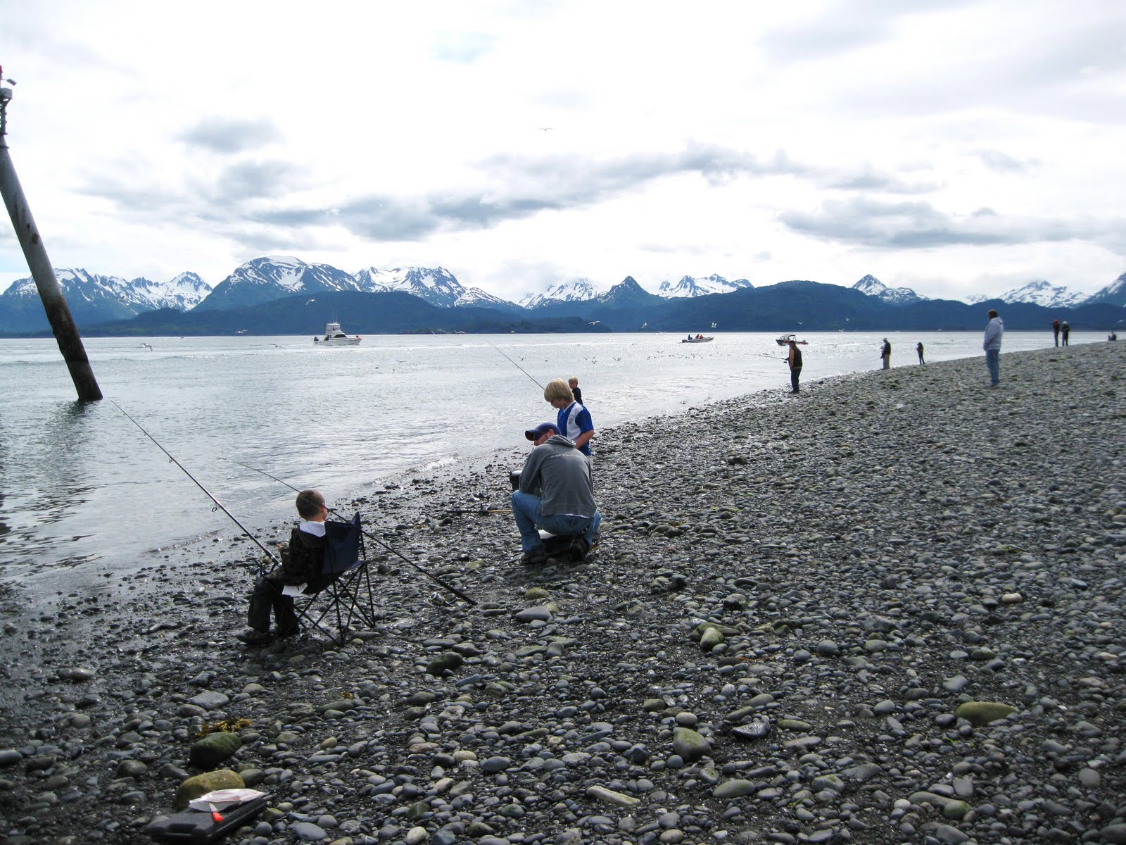
At the very tip of the Spit people lined up night (with the help of the midnight sun) and day to catch bottom fish. The fish were "chummed in" by a nearby cannery, and you couldn't lose.  We saw people walk away with huge buckets full of flounder! 

One of the ever-busy fish cleaning stations in our camping area.

People were not the only ones enjoying the easy catches.

While we were in Homer we met a wonderful couple from Capitola, CA., Peg and Craig.  It was nice to find another couple who liked to play. David and Craig went out on a half-day halibut charter one morning and both caught their limit of 2 fish. We were there over the Fourth of July weekend and shared a wonderful traditional celebration.  First we had a BBQ at the local Elks Lodge which offered spit roasted pig as well as the usual hot dogs and hamburgers. Then we watched the 4th of July parade. 

Nola, David, Peg and Craig

Waiting for the parade along Pioneer Street.

Happy 4th of July!

By this time we had been on our Alaskan Adventure for six weeks and seen some spectacular scenery, met some fabulous people, and had incredible experiences. This day I waved my little flag for "spacious skies"... for "purple mountain majesties" ... for "the crowning of brotherhood" and for the grace shed on America. 
How blessed we are to have the freedom to live our lives the way we choose and let others do the same.

The Gift of a Glacier

What a place to celebrate a birthday!  David booked a glacier cruise and "gave" me a glacier for my birthday.  Lucky me!

There were incredible views as soon as we started sailing out of Resurrection Bay into the Gulf of Alaska.

We were next to the Kenai Fjord National Park and on top of the mountains you could see the Harding Ice Field that feeds the glaciers throughout the park.

 
My first glimpse of the Aialik Glacier!

It was exciting to get closer and closer.  From afar it looked like frozen silence.

Happy Birthday to Me!   6/22/2010

Seeing our "Sister Ship" put it all in perspective.

The Aialik Glacier is called a tidewater glacier because it goes right into the ocean. Rather than receding by melting it flows forward and pieces fall into the water.  The process is called "calving". I kept waiting for this piece to "calve".  The ice is a work of art that looks frozen in time yet it moves three feet a day!
The captain took us close to the glacier so we could hear it moan and groan.  Sometimes it sounded like thunder.  As we watched many small sections of ice fell into the water, but you had to be quick to get a photo.

One last look as we pulled away.  On the trip back to the harbor the crew offers the passengers hot chocolate and chocolate chip cookies.  I was surprised when one of the crew members called my name and asked me to identify myself.  Then he announced to everyone that this was my birthday.  As he passed me the first cookie everyone sang Happy Birthday.

What fun! What beauty! What memories!

Tuesday, July 20, 2010

Seward - Mural Capital of Alaska

When Sarah Palin was governor of Alaska she designated Seward as the "Mural Capital of Alaska".  These are created by the Seward Mural society and are designed by Alaska artists.  The designs are projected onto the walls and the outlined shapes are assigned a number corresponding to a paint color.  Then the Society members and volunteers fill in the colors much like the popular "paint by numbers" paintings.

Mural near the harbor

The Alaska SeaLife Center in Seward is Alaska's only public aquarium and ocean wildlife rescue center.

Wildflower mural


This mural depicts the common wildflowers of Alaska.  Here you can see the Dwarf Dogwood in the bottom left hand corner, the Lupine, the Columbine, Iris and the Forget-Me-Nots, which are the official State flower.

The Iditarod Trail

Siberian Huskies

The Iditarod National Historic Trail is one of 22 national trails managed by BLM (Bureau of Land Management).  This trail is 938 miles from Seward to Nome.  It was used as a major transportion route from 1910 until the late 1920's when airplane use became common.

Iditarod means "distant place". The first race on the trail was held in1973, and now dog sledding is Alaska's official sport.  Many communities have sledding trails on the outskirts of town.  During the summer months the dogs pull sleds with wheels to keep them in shape.  By November there is enough snow to start the races and people compete to qualify to participate in the famous Iditarod. Mitch Seavey, of Seward won the race in 2004 and won $69,000.  He and his dogs did it in 9 days, 12 hours, 20 minutes and 22 seconds.

The next two murals depict legends of the First People.  Next to the murals there were explanations of the paintings and I have copied the words here.  I hope you will enjoy these stories as much as I did.

Raven the Creator

"In the beginning the world was all water.  As Raven flew above he sees Salmon Woman swimming below in the water.  Ever curious Raven swoops down to talk to her.  He becomes enarmored and asks her to marry him.  Salmon Woman agrees, but only if he creates land.  With the help of other sea creatures, Raven obtains sand from the sea bottom, which he drops from above to create the land and islands.  Salmon Woman can now come ashore and dry her hair in the wind."

Raven Releases the Sun, Moon and Stars

"There are many versions of this story in Alaska.  In this one, the world was dark because a Chief has the sun, moon and stars kept hidden away in a box.  Raven discovers this and in disguise as the Chief's grandson, he tricks him into opening the box, thus releasing the sun to give light to the world and the moon and stars to light the night sky."

Seward - Gateway to Kenai Fjords National Park

The trip south to Seward was magnificent.  We drove along the Chugash Mountains and through the Chugash National Forest.  There were snowy mountains on both sides of the road making it feel as if we were driving through a Christmas card!  Vast ... massive ... regal ... there is no one word to describe the majesty of this area.

Our site next to Resurrection Bay in Seward

City camping in Seward

In Seward we went from being surrounded by mountains to being surrounded by water. This picturesque community is nestled right on the edge of Resurrection Bay.  The city of Seward offers camping along most of its shoreline and for only $15.00 a night we had an incredible view across the Bay and access to the harbor and to the town via a paved walking path. (David later checked at a hotel and was quoted $289 a night for a room with a view!)


Boardwalk at Seward's small boat harbor

"Caught in Seward"

In one direction the walking path led us to the small boat harbor and the boardwalk.  It was fun to see all the action.  David and I watched a couple clean the halibut they had caught on a charter fishing trip.  We chatted awhile and then the wife offered to take a picture of us.  Just as she was taking the picture her husband jumped out in front of us.  To make up for his joke he gave us two fillets of halibut for supper.  That was a nice surprise.... and a delicious treat!

This halibut weighed in at 330 lbs!

A face only a mother could love

I learned that halibut start out with their eyes on both sides of their heads, and then the left eye migrates to the right side.  Since they are bottom fish the adapation makes it easier for them to see while they are lying on their bellies.  I wonder if this is evolution happening right in front of our eyes!

The bike path along Resurrection Bay

Obihiro Park

Taking the path in the other direction leads you into town.  On the way you pass through a small park dedicated to Obihiro, Japan, Seward's Sister City in Japan. Years ago David and I went to Kakagawa, Japan, which is Eugene, Oregon's Japanese Sister City. I sent our hostess a copy of this photograph and now she is following my Blog, and also David's blog at http://www.highwaytoadventure.blogspot.com/.
It was wonderful to reconnect with Miyuki this way.  We have many wonderful memories of staying in her family's home.

Mega dandelions

Cow Parsnip

David and I walked into town a few times to use the internet connection at the Senior Center.  In an empty lot next to the Senior Center there were dandelions growing two feet tall and a HUGH cow parsnip plant.
I guess they are the products of the midnight sun.

Being a florist's daughter has made me appreciate flowers.  I enjoy taking pictures of them and identifying them as we travel.  Although my mother has been dead for six years, when I see something especially lovely, or unusal like these overgrown plants, I still think of telling her about it knowing how much pleasure it would give her.

Whittier - Gateway to Prince William Sound

Tunnel through the Chugash Mountain to Whittier

According to the Lazy Daze itinerary we would catch up with the group in Whittier.  They had planned to take a cruise in Prince William Sound and although it was a rainy day, I was more than ready to see more glaciers. 

The Portage Road took us to the 8-lane staging area that controls vehicle traffic entering the Anton Anderson Memorial Tunnel.  The tunnel uses a computerized traffic-control system that regulates both rail and highway traffic.  It took us 6.5 minutes to travel through the tunnel.  It is the longest highway tunnel and longest combined highway/railway tunnel in North America.  David was driving with white knuckles going in because he had to straddle the railway tracks and there was very little shoulder room on either side.  Luckily, the return trip was easier.

Whittier was created by the US Army during WWII as a port and petroleum delivery center for the bases farther north.  The tunnel and railroad spur was completed in 1943 and Whittier became the primary debarkation point for cargo, troops, and dependents of the Alaska Command.  It was strategically valuable because of its ice-free deep-water port.  Since the military activities ceased the economy has depended largely on the port and the fishing industry, and increasingly on tourism.  

David and I checked out the one RV park and did not find any Lazy Daze rigs, so we decided we had missed our friends.  Apparently the weather had been bad for a few days, so they may have left days ago. With the rain, cold wind and poor visibility this was definitely not the time to book a cruise. 

Whittier's main streets were narrow and lined with pickup trucks, so was difficult driving the RV. From the little we saw, the town did not look very inviting.  There are a couple huge buildings that were constructed for military families years ago, and are now used as apartments. We decided to walk around a little and then return to the campground.  We had difficulty finding a place to park and the one huge parking lot near the harbor was jammed with trucks and boat trailers. Whittier is a serious fishing community.  Finally an attendant allowed us to double park without paying, since we were not going to be there for long.


The first thing I had noticed as we exited the tunnel was a trash container cabled to the ground.  Then I read in a brochure that "Portage Pass is a narrow land bridge between Prince William Sound and Turnagain Arm.  As the air pressure between the two areas equalizes, extremely high winds can be created.  These winds have snapped 50 foot flagpoles like twigs, peeled away asphalt, and lifted boxcars from the railroad tracks."  That explained the cabled trash container, and it explained why there is a pedestrian tunnel from the residential area to the harbor and the wharf.


Whittier Harbor with a cruise ship docked


David chatting with some fishermen


This guy lived in Eugene for awhile... now he is a "forever Alaskan"

David got into a conversation with a group of fishermen who had just finished cleaning their catch.  We could see a pile of fresh halibut in zip-locked bags, ready to freeze. After seeing that we started talking about the possibility of going halibut fishing.  That fish looked delicious!


Tourist shops on "The Triangle"

There is a section of shops near the harbor called "The Triangle".  Here you will find all kinds of shops for the tourist.  The people from the cruises spend alot of money here during the summer season, and then these shops close for the winter.

We were told that the islands and the fjords of Prince William Sound were breathtaking. All we could see was a fog bank. I am sure that on a sunny day our experience would have been very different. The day we were there the weather was nasty and nothing looked very inviting. However, we got a good taste of what it would be like to make a living as a fisherman!

We could not wait to return to our cozy site in the Williwaw Campground!


Sunday, July 18, 2010

Portage Valley and the Trail of Blue Ice

Middle Glacier in Portage Valley

What an incredible find!  Without doing much research we ended up in a fantastic campsite in a fantastic location.  Just behind the Williwaw USFS Campground we got this wonderful view of Middle Glacier.  Because this is a United States Forestry Service Campground, our Golden Eagle Pass got us in for half price.  This view.... for only $9.00 a night!


Portage Creek

It was a drizzly day, but we decided to hike the Trail of Blue Ice which was just behind the campground.  It is a boardwalk/paved trail that goes along Portage Creek south of the campground and ends up at Portage Lake.

Portage Lake with Portage Glacier in the background

Over the years, Portage Glacier has advanced and retreated due to climatic changes.  It is reported that it is now receding five hundred feet a year.  Before its present retreat the indigenous peoples, early traders, and miners traveled across the Portage Glacier and the Burns Glacier (next to it) using them as a "portage" between Prince William Sound and Cook Inlet.  Today the railroad and tunnel to Whittier provide this important transportation link.


Here I am taking picture of "calves".  This is an exciting first for me!  I later learned that the Portage Glacier extended to this point in 1939, the year I was born.  The glacier has now receded so far that you can barely see it from the lake.

The Begich, Boggs Visitor Center at Portage Lake

The Visitor Center is very informative and arranged so visitors have a sense of walking up Portage Valley, through Portage Pass and down into Pince William Sound.  My favorite section in the Center is the "Alaskans and Their Stories" room, where I listened to talks about real people who lived in this area.
Just beyond the Center is a small tunnel through a section of the Chugach Mountains.

David.... ready for the  fish and the bear!

Our second day we decided to walk the trail in the opposite direction and have David try his luck fishing along the way.  The camp host warned us that there had been recent bear sightings so we both wore our "bear bells" so we would not startle any bear. We sounded a bit like Santa's reindeer as we walked along, but we rather have the bears run from us than the other way around!

I was sooooo happy to get such a great view of Explorer Glacier

I have often wondered why glacial ice is blue.  A brochure from the Visitor Center explained it well: "The ice is formed under the weight of countless snowfalls, which squeezes out most of the air, leaving dense, compact ice.  Sunlight, or white light, is made up of all the colors of the spectum... with each color having a different amount of energy.  In regular ice, like the ice in your freezer, the air bubbles scatter the light - creating the white appearance.  When sunlight strikes glacier ice, the lower energy colors are absorbed by the ice and only the blue color, which has the most energy, is reflected back to the eye." 

The blue ice of Explorer Glacier

I can't explain my excitement and my interest in glaciers... but I think it has to do with the big picture ... of creation and recreation, and life and death, and change and beauty and the eternal Mystery.