Thursday, November 25, 2010

The Well Made Plans of Mice and Men ... Part Two

I found an "old" friend in Barkerville.

Billy Barker's discovery of gold on Williams Creek in 1862 triggered a stampede of thousands of miners to the area over the next eight years.  Many travelled by way of the Cariboo Wagon Trail which was the route we drove up when we first started our Alaskan Adventure in May. 

Barkersville was a typical gold rush boomtown.  Now it is a unique heritage site, and well worth the visit.  There are over 125 heritage buildings and museums, and lots to do, including live stage shows, mining demonstrations, gold-panning, stagecoach rides, and historic tours of Chinatown.   

Main Street in Barkerville.

David, visiting one of the many buildings in Chinatown.

From Barkerville we drove over to Bowron Lake Provincial Park.  After days of driving we were looking forward to spending three quiet days kayaking on the lake.
We found a campsite and then walked around to get familiar with the park.  David was feeling strong and healthy so he celebrated by doing 50 jumping jacks!

Our campsite at the Bowdon Lake Provencial Park.

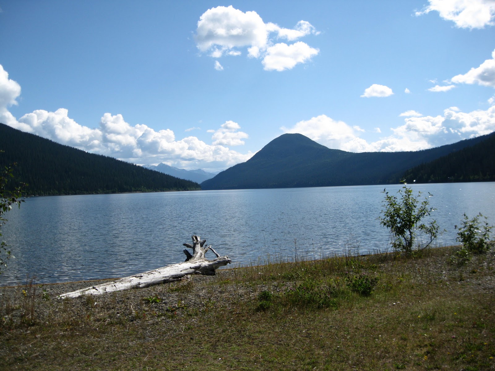
Bowdon Lake beckoned to us.

The next morning we walked up to the Ranger Station to register since we planned to be out on the water for three days. 

However, that was not to be... thwarted again. 

David had been taking a powerful anticoagulant (Plavix) since his "cardiac event" and apparently the jumping jacks had caused internal bleeding. With a history of bladder stones and kidney stones, we could not ignore the blood in his urine.  So we packed up and drove to the closest hospital, which was in Quenel. David spent the night in the ER hoping that the bleeding would stop.  Fourteen hours later we were on our way to see the closest urologist.  We spent two more days at the Regional Hospial in Prince George. We were well taken care of by the Canadian health care system.

We had been thinking about extending our trip to include Jasper National Park in Alberta, meet up with our friends at the Lazy Daze Rally in Idaho and end up at the 100th Anniversay of the Pendelton Round-up in Oregon.  However, our focus had switched and we were eager to get home.

Upon discharge we high-tailed it to the border.

When we first started out on our Alaskan Adventure we saw young shoots of fireweed along the roadsides and in camping areas.  As the summer went by, the fireweed came to full bloom.  Now the flowers were spent, and the tall stems were topped with fluff and seeds which were carried off by the autumn breezes.

It felt like it was our time say goodbye to the summer too. 

Fireweed, at the end of the season.

When we returned to Eugene we checked in with David's doctors and then settled in at the RV parking lot at RiverBend Hospital. He enrolled in the Cardiac Rehabilitation Program for six weeks and graduated with flying colors.  

The main section of RiverBend Hospital.

There's our rig, next door to the hospital.

Behind the RV parking spaces there is a lovely path leading through a stand of old growth trees, to the edge of the McKenzie River. We walked it nearly every day and soaked in the energy of Nature.

This turned out to be a healing time for both of us. 
A time for rest and reflection. 
A time for renewal before our next RV adventure.

The path ... inviting us to keep moving.


Monday, November 22, 2010

The Well Made Plans of Mice and Men... Part One

                                                                             
Saying goodbye to the Alaskan flag.

We arrived in Tok in anticipation of picking up our mail.  Our dear friend, Margo, has forwarded our mail to us all along our travels and we have never had any problems.  It had been well over a month since our last mail pickup so we were eager to get our news.  We were also anticipating a pile of bills and insurance reports from David's hospitalizations in Wasilla and Anchorage. Well, our mail was not there. We considered having it forwarded to a location in British Columbia but the postal clerk warned us that that could take weeks, and suggested we keep the packet within the boundaries of the United States of America. So we arranged to have it forwarded to Sumas, WA, and figured we'd pick it up when we crossed the border on our way home.

We were also anticipating a side trip up to the colorful towns of Chicken and Eagle and then driving The Top of the World Highway into Dawson City in the Yukon Territory. However, the endless rains had caused hugh landslides which washed away part of the road out of Chicken.  Nobody could predict when the road would be repaired and rumors had it that it would remain closed for the rest of the season. 

We put the disappointments behind us as we headed for British Columbia.  We had wonderful memories of the Cassiar Highway and were ready to kayak again at Boya Lake. You can imagine our shock when we learned that the Cassiar Highway had been closed off  because of forest fires! 

Luckily the road opened again day we arrived at the junction with Highway 37. The smell of smoke was in the air as we drove down the Cassiar.  We passed smoldering trees and some small areas that were still in flames. We were happy to land safely at our old site on Boya Lake, and that evening we were blessed by a beautiful rainbow.  

Our lucky rainbow over Boya Lake.

Having had our earlier plans thwarted, we decided to drive to Stewart/Hyder. These two little communities are right on the border of British Columbia and Alaska, at the head of Portland Canal. The attractions here include the Bear Glacier that can be seen from the highway, and the famous Fish Creek bear viewing area.

Main Street of Stewart, British Columbia.

We stayed at Bear River RV Park, just outside of Stewart, and drove up to Fish Creek the next day.  After all the stories of the fantastic bear viewing, we were a bit disappointed when we learned that only one or two bears were still being seen, and they were usually only seen in the early morning or at dusk! We hung around all day and then when it was too dark to take a photograph, a grizzly finally came down the middle of the creek swatting at the water and eating fish as he went. 
The show did not last too long, but was thrilling because it was "real".

David at the boardwalk viewing area at Fish Creek.


We were able to watch the salmon spawning in the shallow water.

Driving back along the spur road we got a wonderful view of Bear Glacier. After all the glaciers we had seen, I still got excited about being so close to one.

Me and Bear Glacier (along Highway 37A)

Next stop... Bowdon Lakes. We planned to take some extra time to visit Barkersville, and then kayak a portion of the famous Bowdon Lake Canoe Trail.
Little did we know that these plans too, would be thwarted! 


Thursday, November 4, 2010

Fairbanks to Tok ... completing our circuit tour of Alaska

The Tanana River Valley south of Fairbanks.

We took the Alaska Highway, Route 2, out of Fairbanks.  The first town we drove through was North Pole. This is a theme city: "Where the spirit of Christmas lives year round."  The street light poles are painted to look like candy canes and many of the streets are appropriately named.... St. Nichols Drive, Santa Claus Lane, and Mistletoe Drive. Many children's letters addressed to Santa Claus, North Pole, end up here. There were Santas at every other shop, but we managed to get through town without getting caught in the glitter of the Christmasy tourist traps. 

The highway follows the Tanana River most of the way.  We stopped at one roadside display that said, "Gold deposits found in 1902 north of the present day Fairbanks proved to be the richest in Alaska..... A second strike in the following summer catapulted a temporary trading post (Fairbanks) into the largest city in the territory."

A braided section of the Tanana River, with the Alaska Range in the background.

As we followed the route in The Milepost, time and again there was a red caution notation... "Watch for moose".  And sure enough, we spotted a moose beside the highway who fled into the woods just as we approached! 

We finally saw a moose when we were not looking for one!

We stopped at Dot Lake which was once an Athabascan hunting camp and a spot on the Indian freight trail to the Yukon River. The area was homesteaded in the 1940's and was a work camp called Sears City during construction of the Alaska Highway in 1942-1943. Dot Lake Lakeside Community Chapel was built in 1949 and is a wonderful example of an old-time Alaskan church.  It is still being used by the local population of 33 people.   

Dot Lake Lakeside Community Chapel, built in 1949.

A view of Dot Lake from the chapel.

We made a point to stop at Dot Lake because David's favorite aunt is named Dot. We picked up a brochure in the chapel, and decided to send it to Dot with a note.  We knew she would get a kick out of this, and it was fun to mail it from the local post office so it would be postmarked Dot Lake.
(The post office is housed in the former Dot Lake Lodge, which is now a private home)

David, mailing the note to his Aunt Dot, in Maine.

Of course this little side trip brought back sweet memories of our trips to Maine and our visits with Aunt Dot.  Every time we go there she spoils us. She stocks up on all David's favorite foods, including Moxie sodas, haddock stew and LOBSTERS!

That's Aunt Dot in the middle...  with me and Uncle John and all the "lobstahs".


Saturday, October 23, 2010

Fairbanks ... a pioneer city

Riverboat Discovery Cruise on the Chena River

Fairbanks was a very pleasant surprise.  It is Alaska's second largest city, but has a population of only 33,000 people! The surrounding area has another 50,000+  people, however, which includes many Indigenous people and makes for a wonderful mix. 

Other RV travellers had recommended that we take the Chena River trip on the stern wheeler, and it proved to be the perfect way to begin our visit.


Sled dogs at the kennel of Susan Butcher,
four-time winner of the 1,100 mile Iditarod Race.

From the ship we were given a demonstration of a bush pilot taking off and landing on the river. Then we stopped opposite the Johnson River Kennels and "chatted" with the staff over a mic system.  We got to meet the puppies and watch a demonstration run by the dogs.

After that, we stopped and toured a typical old Chena Indian village. Our tour guide was a young Athabaskan woman named Jobeth.  She was brought up with what she calls "the old ways", but is now attending the University of Alaska in Fairbanks and majoring in ecology.

Me with Jobeth at the Indian Village.

We walked from one area of the village to another learning about the life of the Athabaskans of interior Alaska. It was interesting to learn that different  furs are used for different purposes.  Thick moose hides make good blankets, and since the guard hairs on the outer caribou hides are hollow, their hides insulate the best and are often used for parkas.  If I remember correctly, the "sun ray" around Jobeth's face is made of ermine fur which will not freeze and keeps the face protected.
The parka that Jobeth modeled costs a cool $20,000 ! 

We also found the fish camp interesting.  There was a fish wheel there, and a drying rack and smoke house for salmon. It was explained that a dog eats one salmon a day during the winter, so it is no wonder that the local people take advantage of their fishing rights.

A fish wheel for catching salmon.

Salmon on drying racks.

Salmon in the smoke house.


For us, the other highlight in Fairbanks is the University of Alaska Museum of the North.  The beautiful building dominated the campus.  It was designed by a woman who wanted to capture the grandeur of the glaciers. Inside the building the sweep of the walls, the design of the staircases and all the interesting angles and corners integrated the structure of the building with the displays.

University of Alaska's Museum of the North.

I spent six delightful hours taking in the displays. I rented an audio guide so that I could hear wildlife calls, Alaska Native languages and details about the individual works that especially caught my eye.  There was a wonderful variety... everything from classic Alaskan paintings, Eskimo clothing and ivory carvings, to a mummified prehistoric bison, and videos on the Bering Land Bridge, umiaks and whale hunting and the salmon life cycle.

Upstairs there is a small room called "The Place Where You Go To Listen".  A single wide bench sits in the middle of the room and there are 16 speakers in the walls and in the ceiling. You are invited just to sit and listen.  This is a unique sound-light environment created by composer John Luther Adams. "This ever-changing musical ecosystem gives voice to the rhythm of daylight and darkness, the phases of the moon, the seismic vibrations of the earth and the dance of the aurora borealis, in real time."  He has somehow tapped into the sounds of the earth. What you hear is an ever-changing composition of the wind and the warmth of the sun and the groans of the earth.  The colors on the walls change with the time of day.  It was mostly yellow when I was first there, and then later in the afternoon a rich blue was creeping up from the floor.  At times the sounds were light and musical and at times they were so deep they seemed to be coming from the belly of the earth. I enjoyed sitting there silently by myself.  When I reluctantly left the room I wished that all the women in my Womens' Group could join me there, and be touched as I had been, by this connection to the sounds of the earth.   

One of my favorite pieces ... caribou antlers and shadows.

The longer we stayed in Fairbanks, the more we liked it.  Our campground , The Chena River State Park, was right at the edge of town and on the city bus line. One day we took the bus to the fairgrounds to attend the Tanana Valley State Fair. There were the usual rides and games, and the unusual  ..... salmon crepes, fried halibut fish 'n chips, the Tundra cartoonist Chad Carpenter, and an agricultural display that would make your eyes pop. 

The Tanana Valley State Fair.

 
Carpenter.... an actual living cartoonist!


The Blue Ribbon cabbage at the fair!

For us the whole town of Fairbanks was like a fair.  We had such fun seeing the sights and talking to the people. It is a city by size but it feels like the Alaskan bush country.  We learned that about half the homes do not have running water or indoor plumbing.  We learned that many people depend on sled dogs or snow machines to get around in the winter. We learned that many of the people depend on subsistence rights and live off the land for most of their food.  And yet.... they have created a lifestyle they would never trade.  One woman told me that the minus 40 degree temperatures don't bother her. She even likes going out to her outhouse at night in the middle of the winter because it is sited so she can sit and admire the Aurora Borealis! 

Ahhh, simple pleasures that brighten life ..... like giant sunflowers!  

Friday, August 27, 2010

Denali ... "The High One"

Mt. McKinley, 20320 feet tall, is America's highest peak!

Between Talkeetna and the entrance to Denali National Park, The Milepost noted 8 different places along Park Highway where there is "a view of Mount McKinley (weather permitting)". The key works are "weather permitting".  The day we drove that route it was overcast and we could only see the lower mountains.  How frustrating!

In reading The Milepost I did learn that Denali means "the high one" in the Native language.

Free courtesy buses take you 6 miles into the park.

We stayed in Riley Camp Ground, near the park entrance for a few days in order to get the lay-of-the-land. While we were there we went to the Visitor Center to watch the video about the park, listen to a   Ranger's lecture on wolves, and take advantage of their wonderful displays of wildlife. One day we took
the courtesy shuttle bus out to Savage River to do some easy hiking along the river trail.
The Savage River.
The Arctic ground squirrel..... the guy at the bottom of the food chain!

Savage River is six miles inside the park and anyone going further must have a permit or be on a tour bus. The trail along the river was pretty flat, and we thought it was a good one for David's first hike since his operation. The only wildlife we saw were little Arctic ground squirrels.  They reminded me of praire dogs.  Later I learned that they are about 2,000 calories each.... a good lunch for everything bigger than they are.


Rather than catch the bus back from there, we decided to walk along the road to the next shuttle stop.  This enabled us to soak in the quiet and the majesty of the panoramic views.  Along the way we scanned the landscape for animals and I was excited when I spotted a HUGH bull moose!  Later David saw a pygmy owl.  Both "finds" were exciting.

A "moose pond" near Teklanika Campground...but no moose.

After four days we moved further inside the park to Teklanika Campground.  One day we took the shuttle bus to Wonder Lake, which is almost the end of the park highway. It was an overcast day and we got to see many animals. We saw two grizzly moms with twins.  They ignored us because they were busy eating soapberries.


Most of the animals were far from the road and difficult to photograph, so I usually just used my binoculars.  And now, since my computer is on the fritz, I am writing this Blog using pictures that were taken by David.

Dall sheep along the park highway.

Caribou!

The second day at Teklanika the sun was out and there was a steady breeze.  We went out again with the shuttle bus and stopped at Eielson Visitor Center for some wonderful views of Mt. McKinley.  On the way back to the campsite we got off the bus again in order to walk along the road in silence. It is impossible to grasp the grandeur of the park, but at least we get a feel of it when we are out there alone

 Denali from the park road.

When we were camping at Riley Campground there was a red fox that wandered by every day, and when we were camping in Teklanika River Campground there was a lynx that made its rounds each night. Not the usual campsite visitors.
In Teklanika we were reminded of the movie "Into the Wild' because it was the Teklanika River that prevented Chris McCandless from leaving his bus in the wilderness, and thus caused his death by starvation. After being here we want to see that movie again.  

This is wild and wooly country and it is good that Denali National Park and Preserve has been established to preserve the wildness and naturalness. It has been only slightly touched by our modern times.  Denali was originally begun as a game sanctuary to protect wildlife and now its 324,420 acres hold a bit of nature in its pristine state, for us and for generations to come.

Unidentified wild thing.


Saturday, August 14, 2010

Talkeetna - Rest and Rebound

David, 24 hours after our 3 am ER visit! 


Since this Blog is a diary of sorts, our experience in Wasilla must be included. I woke up at 3:00 am one Saturday morning to find David in the bathroom feeling sick to his stomach. When he told me that he was also having chest "pressure" and his arms felt "weak" we recognized the classic signs of a heart attack and... we were off! Our GPS located the nearest hospital which turned out to be the Wat-Su Valley Regional Medical Center, thankfully only 5 miles away.

The magic words in an emergency room are "chest pain".  Within 15 minutes David had IV's in both arms, an EKG was taken, blood drawn, and 3 nitroglycerin tablets placed under his tongue.  He was quickly stabilized and then flown by helicopter to Providence Hospital in Archorage.  With the help of our GPS, I followed him in the RV. By 6:30 am I joined David in the cardiac ICU while he waited to see a cardiologist.  

A cardiac catheterization indicated the need for 2 stents, and in less than 12 hours David was feeling A-OK with his new and improved body parts. Oh, the wonders of modern medicine!!

Behind the hospital there is an RV parking lot equipped with electrical outlets. I stayed there during David's hospitalization and we stayed there the day he was discharged so we could decide our next move. We discussed how we had signed up for this crazy life-style, and since he felt fine, we decided to head to Denali National Park as planned.... but slowly.

 Talkeetna .... Authentically Alaskan.

Located at the confluence of the Talkeetna and Susitna Rivers, Talkeetna began as a trading post in 1896, and grew as a riverboat supply base following the Susitna River gold rush in 1910. The population boomed during the construction of the Alaska Rail Road, and then has declined to today's count of 849 .

We heard about Talkeetna when we told people we were on our way to Denali National Park.  We were told over and over again, that the best view of Mt McKinley was from the shore of the Talkeetna River.

      Mt. McKinley under the clouds beyond the Talkeetna River.

Although we were there for three days and never saw the mountain, we still got the feel of it because Talkeetna is McKinley's mountain town.  Climbers from all over the world use this little village as their jumping off point.  We saw Tibetan prayer flags, Korean banners, historic buildings, old log cabins, companies offering rafting trips, fishing trips, flightseeing trips, and glacier landings, grizzled locals, artisans, and lots of tourists like us, just wandering up and down Main Street, taking in the spirit of the place.

One of the most interesting buildings in town is the Talkeetna Roadhouse. In the Bearfoot Travel Guide I read; "In Alaska's mining and trapping days, every town, every river crossing, and every 10 miles on the trail featured a roadhouse, or a lodge, or a small cabin, or even a tent, where travelers could find food, shelter and companionship."
The Roadhouse was initially a supply station, but meals were served there by 1918 and it earned the official title of roadhouse when it got fixed up with a cafe, bedrooms and indoor plumbing in the 1940's. 

         The Roadhouse .... delicious homemade food in a low key setting.

Another unique building is Nagley's General Store. Mr. Nagley followed the early gold miners and trappers and he opened this store in 1921 at Susitna Landing. When the people moved, he did too.  He disassembled and moved his store twice, by river barge.  Eventually he rolled his store down main street Talkeetna on logs, stopping at night to conduct store business! Mr. Nagley accepted gold and furs from the local trappers and miners, and the owner still does today.  At Nagley's you can buy everything from canned goods and bulk items to bug spray and ice cream!

 Historic Nagley's General Store.

Between 1898 and the 1920's, there was a lot speculation about the need to build railways throughout Alaska in order to carry its resources to market.  Most of them were never built, and some tracks that were laid down didn't last long.  I heard that you can still see abandoned trains in the middle of the tundra near Nome! 

Alaska now has only two railroads, The White Pass & Yukon and The Alaska Railroad.  Talkeetna was isolated from the road system for many years, but when the Alaska Railroad was built it ran right through Talkeetna. 

The Alaska Railroad, the lifeline of the interior.

Prior to 1917 the best method of reaching Talkeetna from the south was by steamer or stern-wheeler up the Susitna River, a journey of over 100 miles. Now the cruise line passengers come up from Seward by rail, and then continue up to Denali National Park.
Population centers have grown up along this railbelt and will probably continue to thrive  as long as there are enough of us who are captivated by the history, beauty and adventure of Alaska. 

I think this is the only state that is often written with an exclamation point after its name.  Alaska!

Thursday, August 5, 2010

The Iditarod Trail

Iditarod Trail Race Headquarters in Wasilla, AK.

Parts of the Iditarod Trail go back thousands of years to trade routes used by Alaska Natives.  At the turn of the 20th century transportion between boom towns like Nome, Fairbanks and Valdez relied on river and ocean steamers in the summer and sled dog teams in the winter.  In 1908 the Alaska Road Commission surveyed a trail from Seward to Nome to replace the route from Valdez. Colonel Walter Goodwin and his team measured the distance from Seward to Nome by attaching a cyclometer to his dogsled! This trail was 400 miles shorter than the trail starting at Valdez.

The Iditarod National Historic Trail from Seward to Nome.

After the discovery of gold in the Iditarod country on Christmas Day in 1908, the trail was cleared and from then to the middle 1920's thousands of people and tons of mail, equipment, supplies and gold went over the trail between Seward and Nome.

The goldfields around Iditarod became the fourth most productive district in all of Alaska.  By the winter of 1911, "gold-train" sleddog teams packed with a half ton of gold would make the 3-week run from Iditarod to Seward. It is reported that Wells Fargo dog teams carried over 1,000 pounds of gold to Seward in 37 days. Over 65 tons of gold, or $1.77 billion dollars at today's value, was taken out of the Iditarod district ....  and most of it was taken out by dogsled! 

Joe Redington, Sr., "Father of the Iditarod".

Most of the Trail fell into disuse in the late 1920's as air traffic increased and gold mining decreased. Forest and tundra reclaimed the Iditarod Trail for almost a half a century. Then in 1973 some Alaskans, led by Joe Redington, Sr., reopened the routes and there was renewed interest in the old trail. In order to draw attention to the role dogs played in Alaska's history, Joe and his friends created an epic sled dog race from Anchorage to Nome following the route of the historic Iditarod Trail. This race ultimately revived dog mushing in Alaska, and it is now recognized as Alaska's official sport.

A sled dog "van".
This guy is missing out on the fun.

Twenty-two mushers successfully completed the first race in 1973, with the winner traveling the 1,000-mile distance in just over 20 days. The video explained that the first races had only 3-4 tough competitors, but there are 20-30 these days, and over 70 teams competing. The first race took over 20 days, and last year Lance Macky won The Iditarod for the fourth year in a row with a time of less ten hours! That finishing time was reduced by the advent carbon framed sleds and the advanced breeding of race dogs.

I was interested in the fact that Libby Riddles was the first woman to win the race, in 1985, and for the next three years the title was taken by another woman, Susan Butcher Manley. 

After David and I had toured the Race Headquarters and seen the memorabilia displays and photographs dating back to the first run, we couldn't resist giving it a try. 


This is part of the trail around the Headquarters.

We were seated in a "wheeled sled" with a team of eight sled dogs and our "musher" behind us.  They took us for a little ride through the surrounding woods for a fee of $10.00 each. We figured we were paying by the yard rather than by the mile, but where else could we get an experience like this?!

"HAW GEE!"

We were surprised that "our" dog team looked rather small and a little skinny. However, today's long-distance racing sled dogs are relatively small and sleek compared to the earlier breeds.  Because the racing loads are minimal, the smaller dogs have gotten more popular.


This fella is waiting for his turn to run.

From Alaska Geographic's publication of Iditarod, I learned that "the demand for dogs and sleds skyrocketed with the gold rushes to Alaska....  During one of the big rushes it was said that no stray dogs could be found on the streets of Seattle, having all been rounded up and shipped to Alaska.  Malemutes, huskies, and other breeds were mixed to haul freight and passengers."

While traveling in Alaska I have noticed signs for trailheads and seen trails along the side of the road that could be dog sled trails. There are networks of trails on the outskirts of many communities. In Soldotna I saw a sign for Peninsula Sled Dog and Racing and I hiked to the trail head just to check it out.  I found a kiosk there, with a map showing the various trail options ranging from 3-14 miles, and I got to see how the trail looks as it leads into the woods. Many of these trails are multi-use trails and shared with bikers in the summer and snowmobilers in the winter.


Trail head sign.

Kiosk showing the trail options from here.

The trail leading out into the woods.

We have heard stories of dog kennel owners feeding their dogs dried salmon.  That was even mentioned in James A. Michener's Alaska. Recently I read a bit of trivia on a restaurant menu that claimed that beaver is a favorite food mushers feed sled dogs during long distance races because it contains 34.9 grams of protien in 100 grams of meat. Maybe dogsledding saves gas.... but it is not free.

Our fee for the ride paid for some of the dog food.

In the Headquarters, David and I watched a very interesting and beautiful video of the 2009 Iditarod Race. It gave us a good idea of the challenges of the race.  The trail goes through forests, over rivers, across mountain passes and along the windy coast of the Bering Sea.  There are strict rules and check-in points that help keep it safe for the mushers and their dogs.  The video stressed the bond that is created between the owner and the dogs, and how crucial that is during a long distance race.  Also, it stressed the importance of the breeding of the dogs and how each kennel keeps accurate breeding records to improve their future racing dogs.  

A Siberian Husky.

Racing dogs of the future.

Here's to the future of dog sled racing! This is a unique sport that definitely caught my interest. I just bought a copy of "Race Across Alaska ... First woman to win the Iditarod tells her story" written by Libby Riddles and Tim Jones.

I agree with Joe Redington, Sr., The Iditarod helps to keep alive the history of Alaska and I am eager to relive Libby's experience on the trail in 1985!